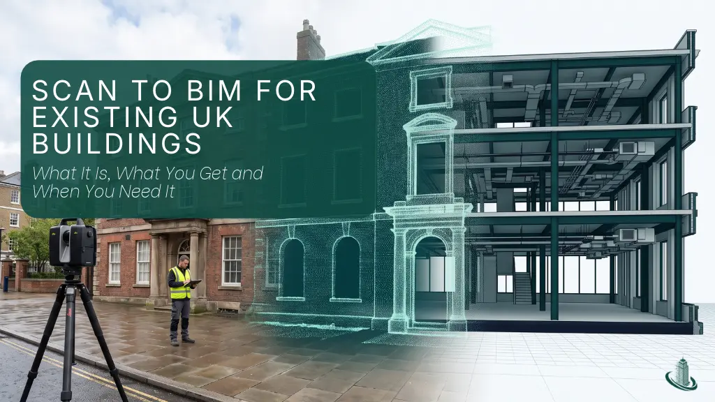
An architect preparing to refurbish an existing building often starts with whatever information is available. It might be an old set of architectural drawings, a few structural plans or records left behind by a previous owner. Sometimes, there is very little to work with.
The problem usually becomes apparent when the design work begins. The actual wall location may not match the position indicated in the original drawings. A ceiling has been lowered to accommodate services that never appeared on the original plans. Structural members have been altered, or an extension has changed the building’s layout over the years.
These differences might look small during an initial site visit. They can become expensive once contractors begin preparing construction details or engineers start coordinating new systems.
This is where Scan to BIM can help.
By combining 3D laser scanning with Building Information Modelling (BIM), project teams can create a digital representation of an existing building based on measured site conditions. Instead of relying entirely on old drawings or manual measurements, they have a more dependable starting point for design, coordination and refurbishment.
But what exactly does the process involve? Does every building need a full BIM model, and what should a client expect to receive at the end?
Let’s look at how Scan to BIM works for existing UK buildings and where it makes the most practical difference.
What Is Scan to BIM for Existing Buildings?
Scan to BIM is the process of converting measured survey data, usually captured through 3D laser scanning, into a structured digital building model.
The process starts with a physical building. A laser scanner captures millions of measurement points from visible surfaces, including walls, floors, ceilings, columns, beams, roofs and other architectural or structural features.
These measurements are processed into a dataset known as a point cloud.
A point cloud is a collection of individual points representing the surfaces and geometry of the scanned environment. When viewed in suitable software, it can look like a three-dimensional image of the building. However, it does not automatically contain the intelligence of a BIM model.
For example, a point cloud may show the outline of a concrete column. A Revit model developed from that data can represent the column as a structural element with defined dimensions, location, material information and other agreed properties.
This distinction matters.
A scan records what the scanner can see. BIM modelling interprets that information and organises it into building components that professionals can use.
The final model can represent architectural, structural and MEP (mechanical, electrical and plumbing) elements, depending on the survey coverage and agreed scope.
What Does This Mean for an Existing Building?
It gives the project team a digital reference of the building as it stands at the time of the survey. This can be particularly useful when the original design information is incomplete, outdated or no longer reflects the physical structure.
How Does the Scan to BIM Process Work?
A Scan to BIM project involves more than placing a scanner inside a building and exporting a 3D model. The quality of the final deliverable depends on how the survey is planned, how the data is processed and how accurately the building elements are modelled.
The workflow generally follows these stages.
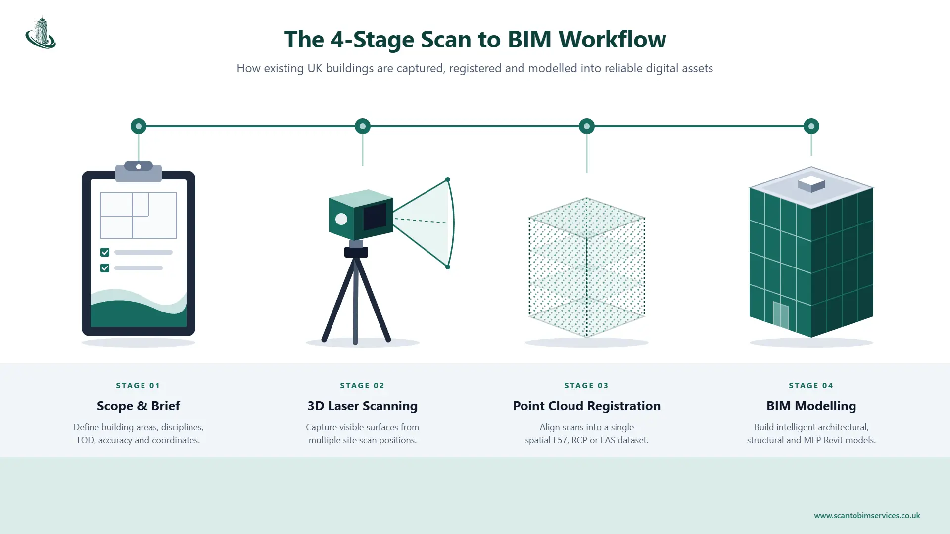
The four core stages of a Scan to BIM workflow for existing UK buildings, from initial scope and laser scanning through to point cloud registration and BIM modelling.
Reviewing the Existing Building and Project Requirements
Before scanning begins, the project team needs to understand why the model is required.
An architect planning a building extension may need accurate floor layouts, elevations, openings and roof geometry. An MEP consultant working on a commercial retrofit may be more concerned with plant rooms, ductwork, pipework, cable trays and service routes.
The required information will be different.
At this stage, the survey and modelling teams should establish:
- The building’s size, layout and general complexity
- Available architectural and structural drawings
- Whether the building is occupied or operational
- The areas that require scanning
- Required modelling disciplines
- Expected geometric accuracy and level of detail
- Coordinate systems, project datum and reference grids
- Required software and exchange formats
Existing drawings are still useful, even when they are outdated. They can help the survey team understand the building before visiting the site and identify areas that may need closer attention.
The important thing is not to treat those drawings as verified site information.
Capturing Existing Conditions Through 3D Laser Scanning
Once the scope is agreed, the survey team captures the building using 3D laser scanning equipment.
A terrestrial laser scanner sends out laser pulses or beams and measures their return to calculate distances. By recording measurements from different positions, the surveyor builds a detailed spatial dataset of the building.
Scanners are generally positioned at multiple locations to capture different parts of the building. The scans are then aligned to create a combined dataset.
This process is known as scan registration.
For larger buildings, several scans may be required to capture corridors, rooms, staircases, structural areas and external elevations. The surveyor also needs to consider access restrictions, temporary obstructions and areas that cannot be reached.
The scanner only records surfaces it can see. It cannot automatically capture hidden pipework behind walls, structural connections above inaccessible ceilings or services inside closed shafts.
This is an important limitation to understand before commissioning a survey.
Historic England recognises 3D laser scanning as a useful technique for recording historic structures, examining architectural details, monitoring structural conditions and supporting conservation planning.—SOURCE
Processing and Registering the Point Cloud
After scanning, the individual datasets are processed and aligned.
This stage is important because scans captured from different positions must share a consistent spatial reference. If the alignment is incorrect, the resulting point cloud may contain misplaced geometry or inconsistencies.
The survey team checks the registration, reviews the coverage and prepares the dataset for modelling.
Depending on the equipment and project requirements, point cloud data may be supplied in formats such as:
- E57
- RCP and RCS
- LAS or LAZ
- PTS or PTX
The exact format depends on the scanning software, the receiving platform and the client’s requirements.
The registered point cloud becomes the reference for the modelling team.
At this point, the project has a detailed record of the scanned surfaces, but the BIM model still needs to be created.
Turn your raw E57, RCP or LAS scan data into a clean, coordinated Revit model built to your project’s exact Level of Information Need.
Explore Point Cloud to BIM ServicesDeveloping the BIM Model
The modelling team uses the processed point cloud as a reference to create building elements in BIM software, commonly Autodesk Revit.
When Do You Need Scan to BIM for Existing Buildings?
Heritage and Listed Buildings
A digital record can support architectural analysis, conservation planning and the documentation of existing conditions.
The modelling approach needs some care, though. Historic buildings do not always follow modern construction patterns. Walls may be uneven, floors may slope and decorative features may not be perfectly symmetrical.
Forcing every element into standardised BIM geometry can remove information that is important to the conservation team.
The required level of detail should reflect the building’s character and the purpose of the survey.
Structural Alterations and Building Extensions
When an existing property is being extended or structurally modified, engineers need to understand how the current building is arranged.
Scan to BIM can help document visible columns, beams, slabs, structural grids and roof members.
This information provides a useful starting point for developing alteration proposals and coordinating new construction with the existing structure.
However, the model should not be treated as a structural condition assessment. Hidden defects, reinforcement arrangements and material properties may require separate investigations.
Facilities Management and Asset Documentation
Building owners and facilities managers sometimes inherit properties with incomplete records.
A BIM model can help establish a digital reference for the building and, where required, support the management of spaces and maintainable assets.
This is particularly relevant for larger estates, healthcare buildings, educational facilities and commercial properties.
The model’s usefulness for facilities management depends on the information included. A geometrically accurate building model without asset identifiers or maintenance data may have limited operational value.
The UK Government’s Facilities Management Standard 002 sets expectations for consistent asset registers, data quality, accessibility and ongoing validation across the central government estate. —SOURCE
What Types of Existing UK Buildings Can Benefit from Scan to BIM?
Scan to BIM is not restricted to new commercial developments or large construction projects. It can be applied to different building types, although the survey approach and modelling requirements will vary.
| Building type | Typical Scan to BIM application |
| Commercial offices | Refurbishment, space planning and MEP upgrades. |
| Residential blocks | Flat layouts, structural alterations and building upgrades. |
| Schools and universities | Extension planning and facilities documentation. |
| Hospitals | MEP replacement and complex service coordination. |
| Industrial buildings | Structural documentation and machinery layout planning. |
| Listed buildings | Conservation records and architectural documentation. |
| Warehouses | Structural assessment support and redevelopment planning. |
| Hotels and hospitality | Interior refurbishment and services coordination. |
The building’s age is not necessarily the deciding factor. What matters is the complexity of the existing conditions and how much reliable information the project team needs.
An older building with good measured drawings may require limited additional survey work. A relatively modern building with several undocumented alterations might need a more extensive scan.
Scan to BIM vs Traditional Measured Building Surveys: Which Do You Need?
These two approaches are related, but they do not produce the same type of information.
A traditional measured building survey generally produces drawings such as floor plans, elevations and sections. A Scan to BIM workflow uses measured survey data to create a structured 3D model.
Laser scanning can also form part of a measured building survey, so the distinction is not necessarily the surveying equipment. It is often the final deliverable.
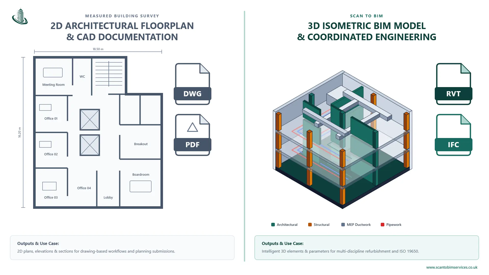
Traditional measured building survey outputs (2D CAD floorplans and PDFs) compared with a coordinated 3D isometric BIM model containing architectural, structural, and MEP data.
| Comparison | Measured Building Survey | Scan to BIM |
| Main output | 2D drawings and measured information | Structured 3D BIM model |
| Typical formats | DWG, PDF | RVT, IFC and agreed supporting formats |
| Main use | Building documentation | Design, coordination and information management |
| Element intelligence | Generally limited | Can include structured BIM elements and parameters |
| Best suited for | Drawing-based workflows | BIM-based refurbishment and coordination |
If a contractor only needs an updated floor plan, a full BIM model may be unnecessary.
However, when several disciplines need to work with the same existing building information, Scan to BIM can provide a more useful starting point.
The choice should be based on the work that follows, not simply on which technology appears more advanced.
What Are the Limitations of Scan to BIM?
Scan to BIM provides valuable information, but it is not a complete record of everything inside a building.
Understanding its limitations helps avoid unrealistic expectations.
Hidden Building Elements Are Not Automatically Captured
Laser scanners record visible surfaces. They do not see through concrete, plasterboard, insulation or other building materials.
A pipe concealed above a ceiling or reinforcement embedded within a slab will not appear in an ordinary point cloud.
Additional investigations, opening-up works, existing records or specialist detection equipment may be needed.
Accuracy Depends on Survey Planning
A point cloud can contain millions of points and still have gaps or registration errors.
Poor scan coverage, unsuitable scanning positions, movement between scans or incorrect alignment can affect the reliability of the dataset.
Survey specifications should define the required accuracy, coverage, coordinate system and verification process before work begins.
A BIM Model Involves Interpretation
Modelling is not simply tracing every point.
A modeller must interpret what the scanned geometry represents and decide how to represent it using BIM elements.
Irregular walls, curved surfaces, complex roof structures and historic details can require more judgement than standard building components.
Two models created from the same point cloud may differ because of their modelling approach and agreed scope.
The Model Can Become Outdated
A Scan to BIM model represents the building at the time of capture.
If construction work, alterations or equipment replacements take place afterwards, the model may no longer represent current site conditions.
It needs to be updated when the project requires an accurate record of those changes.
What Should You Check Before Appointing a Scan to BIM Service Provider?
Before commissioning a Scan to BIM project, clients should spend some time defining what they actually need.
A clear brief can prevent unnecessary modelling, repeated revisions and misunderstandings about the final deliverables.
Here are some points worth discussing.
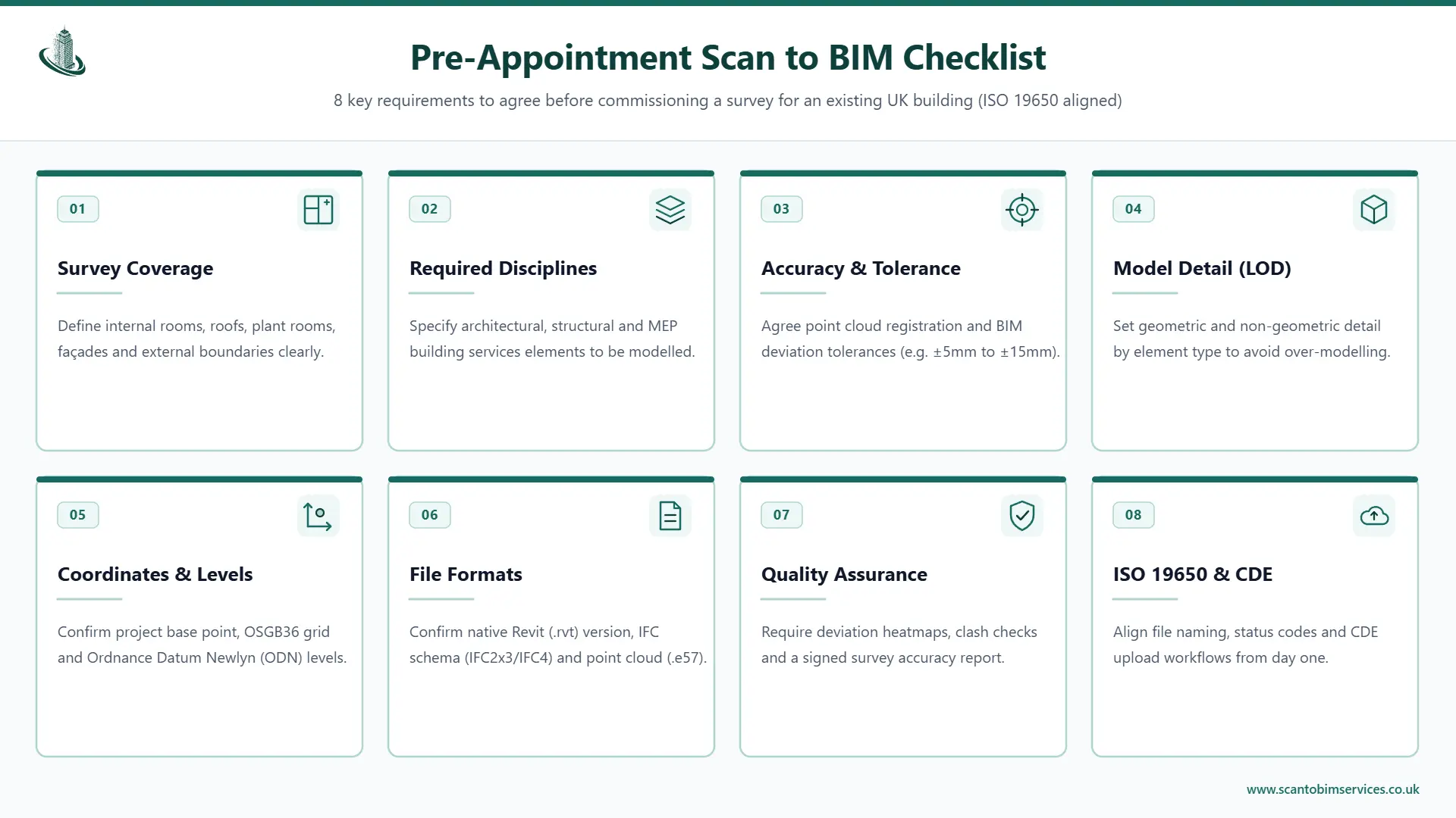
Traditional measured building survey outputs (2D CAD floorplans and PDFs) compared with a coordinated 3D isometric BIM model containing architectural, structural, and MEP data.
Survey coverage: Which parts of the building will be scanned? Are external elevations, roof spaces, plant rooms and service areas included?
Required disciplines: Do you need architectural modelling only, or should structural and MEP elements also be included?
Accuracy requirements: What measurement tolerance is required for the intended design or construction work? Ask how the survey accuracy will be checked and reported.
Model detail: Specify the required Level of Detail (LOD) and Level of Information Need for individual elements or disciplines.
Coordinates and levels: Confirm the project datum, grid, shared coordinates and any requirements for alignment with existing project models.
File formats: Confirm the required Revit version, IFC export, point cloud format and any drawing deliverables.
Quality assurance: Ask how the model will be checked against the registered point cloud and how incomplete or uncertain areas will be identified.
Information management: Where the project follows ISO 19650, confirm the naming conventions, information exchange requirements, revision controls and Common Data Environment (CDE) arrangements.
A provider should be able to explain its modelling assumptions and identify what is not included in the scope. A confident promise of a complete model is less useful than a clearly defined and verifiable deliverable.
How Does ISO 19650 Relate to Scan to BIM Projects in the UK?
For UK projects that follow a structured BIM process, information management is just as important as the geometry of the model.
The BS EN ISO 19650 series provides a framework for managing information across the lifecycle of built assets. It covers how project information is produced, organised, exchanged and managed.
For Scan to BIM projects, this can influence several parts of the workflow:
- How survey information is named and organised
- How modelling responsibilities are defined
- How information is reviewed and approved
- How revisions are controlled
- How models are exchanged with other project teams
- How information is prepared for future asset use
ISO 19650 does not prescribe a single method for laser scanning or dictate how every building element must be modelled. The project team still needs to establish suitable survey specifications, modelling requirements and acceptance criteria.
The UK BIM Framework identifies BS EN ISO 19650-2 for the delivery phase of assets, BS EN ISO 19650-3 for the operational phase and BS EN ISO 19650-4 for information exchange.—SOURCE
For building owners, this is particularly relevant when a Scan to BIM model is intended to support more than one refurbishment project or become part of the property’s long-term information records.
How Scan to BIM Services Support Existing Building Projects
The work involved in Scan to BIM can vary considerably between buildings. Some projects require architectural modelling from an existing point cloud, while others need a combination of architectural, structural and MEP information.
A service provider should be able to work around the project’s requirements rather than applying the same modelling specification to every building.
At Scan to BIM Services UK, our Scan to BIM services cover architectural, structural and MEP modelling from measured survey data, tailored to the exact scope and accuracy your project requires.
For a refurbishment project, the first step should be to establish which information is required and whether suitable scan data already exists.
If the client has an existing registered point cloud, modelling may be able to start without arranging another site survey. If no suitable survey data is available, the project will need a separate scanning exercise.
This distinction can affect the project programme, scope and overall cost.
Conclusion
Existing buildings rarely match their original drawings perfectly. Years of alterations, repairs and changes in building use can leave architects and engineers working with incomplete information.
Scan to BIM provides a way to document these conditions and turn measured survey data into a structured digital building model.
Its value depends on how well the survey and modelling work are planned. A point cloud with poor coverage will not produce a reliable model, and a highly detailed BIM model is not necessarily useful if it contains information the project team does not need.
For UK refurbishment, retrofit, heritage and redevelopment projects, the sensible approach is to start with the intended use of the model. Establish the required accuracy, identify the elements that need modelling and agree on the final information deliverables.
When these decisions are made early, Scan to BIM can give project teams a much clearer understanding of the buildings they are working with, before design decisions become construction problems.
Already Have a Registered Point Cloud?
Turn your raw E57, RCP or LAS scan data into a clean, coordinated Revit model built to your project’s exact Level of Information Need.
Start with reliable, measured existing-building data before design decisions become site problems. Share your drawings, point cloud or project brief with our team to get a clear scope and turnaround estimate.
Contact Us for a Quote